Global Positioning System (GPS) enabled devices and services are quite common for modern day technology such as computers and cell phones, and many current users interact with systems benefiting from GPS daily. The underlying concept behind GPS was once considered relatively exotic, and was used primarily by governments.
GPS enabled devices work by speaking to a loose network of navigational satellites called the Global Navigation Satellite System (GNSS) that continually orbit the earth at a variety of orbital altitudes and speeds. GNSS satellites continually transmit a weak radio signal that devices on the ground can detect. A GPS enabled device requires concurrent line of sight to at least three GNSS satellites to triangulate is position on the earth. Navigational satellites were first launched in the 1970s by the United States government for military use only, however by the mid-1990s GPS had become widely available for commercial use. Today, the GNSS constellation is made up from dozens of satellites from a variety of countries.
Using GPS Coordinates
GPS enabled devices communicate in a coordinate system, which are generally known as “GPS Coordinates”. GPS coordinates define an exact location the surface of the earth within a pre-defined grid system. There is more than one grid system used, however the vast majority of communications systems are built on latitude and longitude:
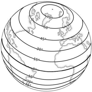
Lines of Latitude – Lines of latitude are horizontal lines that stretch from east to west across the globe. The longest and main line of latitude is called the Equator.
The Equator is represented as 0° latitude, while the north and south poles are both represented as 90°. The space between the equator and the poles are evenly distributed between 0 and 90.
Latitude lines are expressed as 0-90° North (N) and 0-90° South (S), written as (example):
32° N |
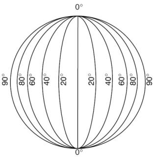
Lines of Longitude - Lines of longitude are vertical lines that stretch from the North Pole to the South Pole. The main line of longitude is called the Prime Meridian.
The Prime Meridian is represented as 0° longitude, while vertical lines east and west increase incrementally until 180°, making 360° in total.
Longitude lines are expressed as 0-180° East (E) and 0-180° West (W), written as (example):
163° W |
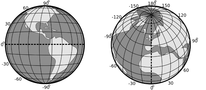
Combined together, the grid structure generated from combining longitude and latitude would look like:
To more accurately describe GPS coordinates, the lines of longitude and latitude are broken down into smaller and smaller increments. Detailed incremental GPS coordinates can provide accurate locations anywhere on the earth’s surface to down to less than a square meter.
In all GPS coordinates, the North/South orientation is always expressed first, followed by the East/West orientation. Unfortunately, there are multiple methods of expressing these coordinates, and they are not interchangeable. The different GPS coordinate formats are:
| GPS Coordinate Grid Type | Explanation | Example GPS Coordinate Layout |
|---|---|---|
| Degrees, Minutes, and Seconds (DMS) | The most common historical method of expressing GPS coordinates was in degrees, arc minutes and arc seconds. While the degree number matches the line of latitude and longitude, minutes and seconds are expressed in units of 1-60, with sixty arc minutes in a degree. Traditional coordinates also require a N, E, W, or S to indicate their relation to the equator or prime meridian, as the numbers alone can represent different locations. | 41° 49' 17.3" N,12° 24' 27.0" E |
| Decimal Degrees (DD) | Decimal degrees are quickly becoming the most common method for expressing GPS coordinates, as they are the easiest to read and understand for computer systems. A decimal degree is expressed as a whole degree (latitude or longitude number) followed by a decimal point and up to six numbers past the decimal point. The numbers past the decimal point are essentially fractions of a whole degree, and based on units of 1-10. Decimal degrees west of the prime meridian or south of the equator are expressed as negatives. As an example, a point off the cost of Peru (both in the southern hemisphere and western hemisphere) would be expressed as: -9.791500, -81.199971 | 41.821468,12.407512 |
| Degrees and Decimal Minutes (DMM) | A hybrid between regular arc minutes/seconds and decimal degrees, where the regular arc minutes and seconds are expressed in decimal format. | 41 49.2881 N,12 24.4507 E |
When generating and using GPS coordinates, it is important to understand the differences between the different formats! Because arc minutes and seconds use a base 60 system while decimal degrees use a base 10, the same location will have two different numbers. If someone is recording GPS coordinates from a device that reports in arc minutes/seconds, users must remember to convert the coordinates to decimal degrees if they plan on using tools that require decimal degrees, and vice a versa.
GPS Devices
There are number of GPS devices available on the market for humanitarian organisations, all of which will have their own user requirements and instructions. It is important that users understand what the intended use of the GPS device is when making a selection.
Offline/Standalone – Many GPS devices are designed for the sole purpose of taking GPS readings. Usually these devices have a simple interface, and a powered by disposable or rechargeable batteries. Offline GPS units are frequently used for maritime, aviation and military, but are also use for wilderness orientation, extractive industries, or any application that requires being far away from a mobile or internet connection. Offline GPS devices are generally just passive receivers of GPS signals from GNSS satellites, and will provide a flat set of coordinates when in use. Some GPS devices have mapping functions or the ability to leave waypoints. The need for these additional features will depend on the use and the agency.
Online/Phone Based – Most modern smart phones come with GPS capability, as well mapping and tracking applications. While most users are familiar with phone based GPS apps, there are a few important things to consider:
- Many phones also triangulate position based on mobile phone towers, and may not necessarily be getting a solid GPS reading from a GNSS satellite.
- Phones may be delicate, be less water/dust resistant, and have shorter batter lives than dedicated GPS devices.
- Without persistent connection to the internet, some GPS apps will not work.
Before relying on a smart phone as a primary GPS device, users should consider:
- How long will the device be required to operate for?
- Will the device withstand the environmental conditions required for the operation?
- Will this smart phone actually work without cellular connection?
